When geologists see a straight line running across a landscape, they get suspicious. Straight lines don’t happen by accident; they usually mean something. Such a line, about 155 miles long, leads north out of Grand Canyon country into Utah. It’s called the Hurricane Fault. Nineteenth-century geologist Clarence Dutton declared this one of the Earth’s most interesting “dislocations.”
The Hurricane is a normal fault -- it’s slipping vertically as rocks on either side are being stretched apart, with the west side dropping down and the east side rising up. Take two blocks of wood -- shift the one in your right hand up and at the same time shift the other one down -- and you’ve got the basic idea.
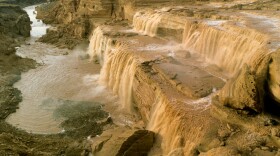
The Hurricane Cliffs are the visible trace of the fault. The offset – or “dislocation” as Dutton called it -- varies from a couple hundred feet in Arizona to a couple thousand feet or more in Utah. Travelers on I-15 between Saint George and Cedar City drive alongside these sheer, rainbow-colored cliffs which border the Kolob District of Zion and chisel the face of Cedar Breaks.
Local folks are well aware of these cliffs, because many of their ancestors went up and down them in wagons. In the late 1800s, freighters hauled huge ponderosa logs from Mount Trumbull back to Saint George to build the Mormon temple. And newlyweds forged the Honeymoon Trail down the imposing cliffs on their way to the temple to have their marriages sealed.
Hurricane -- and around here it is pronounced HER-a-kin -- is the name given to the fault, the cliffs, and a small town in southwest Utah. The name is credited to church leader Erastus Snow.
Nathella Bundy Wood, who lives in the town of Hurricane, knows how the fault got its name.
"Honey, there was a member of the LDS Church was down here and they were trying to decide when they were up here on the fault …way up here on the fault," she remembers. "And a big old wind come up and blew the top of his buggy…blew the top…and he said “Man, wasn’t that a hurricane!”
She grew up in the shadow of the cliffs at Bundyville, down on the Arizona Strip……
"Well I can tell you for sure I wouldn’t trade my childhood for anything," Wood said. "I’ve never been unhappy about growing up there and it’s still home."
The Hurricane is one of several parallel faults which collectively form the boundary between the Colorado Plateau to the east, and the Basin and Range province to the west. The Hurricane Fault first became active about 25 million years ago when the Basin and Range started to stretch apart. A little later the Colorado Plateau began to rise, hoisted a mile and more above sea level. An orderly and for the most part undeformed layer-cake, the Plateau stands in stark contrast to the disheveled Basin and Range province.
For the last few million years, the Hurricane Fault has been influencing the Colorado River’s course in western Grand Canyon. The fault chewed up rocks and created a line of weakness that helped steer the river as it carved the Canyon.
Today geologists keep a close eye on the Hurricane Fault because it’s still active. In 1992, a Magnitude 5.8 earthquake centered on the fault unleashed landslides that wiped out houses in southeast Utah. Nathella felt her bedroom floor shake.
"It was scary," she said. "It woke me up and things were falling off my walls. You could hear it rumbling."
So beware those straight lines in nature. That’s where you just might feel the Earth move.


